Q1Why is the National Gravity Reference Station needed and what equipment does it host?
A:
The Ministry of the Interior (MOI) is responsible for developing national surveying, including the establishment of national horizontal, vertical and gravity references. Since 2003, advanced equipment and techniques have been introduced to establish geodetic (satellite tracking stations), height (the Taiwan Vertical Datum) and gravity (the National Gravity Reference Station) datums for nationwide use. Major equipment includes a superconducting gravimeter, relative gravimeter, absolute gravimeter, airborne/shipborne gravimeters, a velocity seismometer, GPS receivers and a suite of environmental sensors (data logger, anemometer, hygrometer/thermometer, barometer, rain gauge, water-level/temperature sensor, soil-moisture sensor, etc.).
Q2Why is the station located inside the Shibajianshan tunnel in Hsinchu?
A:
A precedent is the European Center for Geodynamics and Seismology in Luxembourg, expanded inside an abandoned mine (http://www.ecgs.lu/). The Bo-ai main tunnel of Shibajianshan in Hsinchu offers structural integrity, a low water table, low vibration and easy access. After favourable site evaluations by gravity experts from Germany and Japan, MOI obtained the use of the tunnel from the Ministry of National Defense, signed a contract with ITRI in August 2004 and accepted the completed station in December 2006.
Q3How is the absolute gravity value at LOGG determined as the national reference?
A:
An absolute gravimeter is used at a permanent pier for at least 12 hours of measurements to obtain the absolute gravity value at 100 cm above the pier. The raw observations are then reduced to standard conditions (standard atmosphere, no polar motion, average groundwater level, average soil moisture, etc.) so that the value is time-invariant; tidal effects of the solid Earth and ocean loading are also removed. A relative gravimeter is then used to measure the local gravity gradient, transferring the value from the 100 cm height to the pier surface, which is provided as the official reference for further surveys.
Q4Earthquakes are frequent in Taiwan—how is the LOGG absolute gravity value kept accurate?
A:
Absolute gravity observations are repeated periodically at the permanent pier; control charts are produced, anomaly sources analysed and the absolute value updated regularly. The continuous record of the superconducting gravimeter is also used to study relative gravity variations caused by environmental change, which provides additional verification.
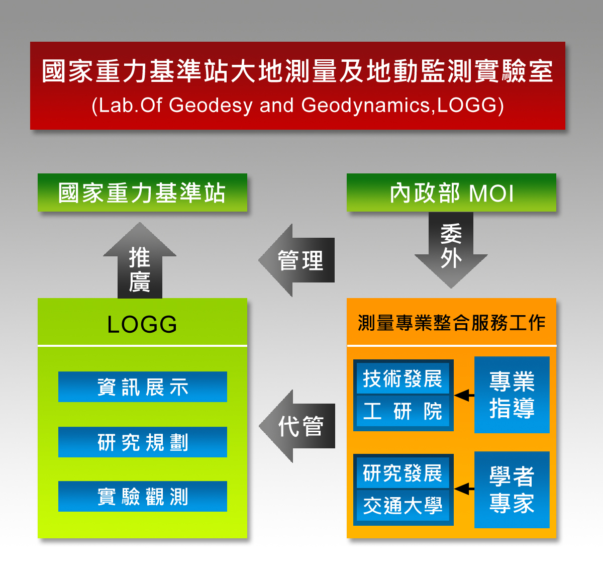
Q5How is LOGG organised and operated?
A:
MOI is the top-level authority of LOGG. Commissioned by MOI, the principal investigator oversees the activities of the Laboratory of Geodesy and Geodynamics and conducts long-term gravity monitoring. The full organisational chart is shown.
LOGG organisational chart
Q6What is the difference between a relative gravimeter and an absolute gravimeter?
A:
They differ in measurement principle and in the physical meaning of the value produced. A relative gravimeter measures the difference of gravity between stations (or at the same station at different times); an absolute gravimeter measures the acceleration at the station itself, i.e. the absolute gravity value.
Q7How does a relative gravimeter work?
A:
Take the Graviton-EG as an example: an inclined zero-length spring inside the instrument extends in proportion to gravity, so by measuring the extension one obtains the relative gravity difference between stations (or between different times at the same station).
Q8How does an absolute gravimeter work?
A:
Using the FG5 as an example, absolute gravity is derived from two fundamental quantities—distance and time—measured during a free-fall experiment. By precisely tracking the distance/time relationship, the gravitational acceleration, i.e. the absolute gravity value, is obtained.
Q9What are the operational limitations of a relative gravimeter?
A:
For the Graviton-EG, the spring sensor must be held at about 50 ℃, so it must remain plugged in even when idle and run on battery during fieldwork. If the sensor cools down, it must be re-warmed for at least 48 hours to return to a stable operating state.
Q10What are the operational limitations of an absolute gravimeter?
A:
The FG5 requires an environment of 15 ℃–30 ℃ and a stable 100–240 V power supply. Strong winds and microseisms degrade data quality, so a wind-shielded (indoors or with windbreaks) and vibration-isolated (stable bedrock or isolation platform) environment is required.
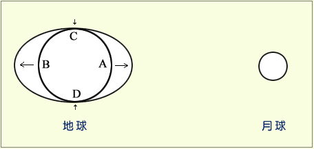
Q11What are solid Earth tides and ocean tides?
A:
The Earth can be regarded as a solid body that deforms periodically under the gravitational pull of the Sun and Moon. Although the Sun is more massive, the Moon is much closer, so its tidal force is about 2.25 times stronger than the Sun's. As the relative positions of the Sun and Moon change, the shape of the Earth changes accordingly—this is the solid Earth tide. The familiar daily rise and fall of the sea is also driven by the Sun and Moon, hence ocean tides vary with their positions.
Tidal forces from the Sun and Moon deforming the Earth
Q12What is superconductivity and how is it used in gravity measurements?
A:
Superconductivity is the phenomenon by which the electrical resistance of a material drops to zero below a certain critical temperature, accompanied by perfect diamagnetism. A superconducting gravimeter exploits this effect: a superconducting sphere is levitated inside a Dewar (cryogenic vessel) without resistance, and any disturbance below the surface or change in surrounding mass causes the sphere to shift. Coils around the sphere automatically record the displacement. The instrument can resolve gravity changes finer than 10⁻¹¹ m/s², detecting extremely small environmental variations.
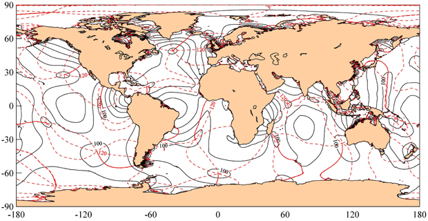
Q13What is an ocean tide model and which models are commonly used?
A:
Because tides at different periods exhibit different patterns, the periods themselves are used to distinguish ocean-tide models. For example, the M2 tide derived from the FES02 model is usually displayed with the amplitude as a solid black line and the phase as a dashed red line. Beyond FES, widely used ocean-tide models include CSR, TPXO, GOT and ORI, all of which combine satellite altimetry with periodic mathematical formulations.
M2 ocean tide component from FES02 (solid: amplitude; dashed: phase)