Development History
National development depends fundamentally on measurement systems. The more advanced and industrially developed a country becomes, the higher the precision required of its metrological infrastructure.
Surveying and mapping—the foundation of national construction, land-use planning and the protection of people's rights—has been continuously upgraded by the Ministry of the Interior (MOI) since 1993, when high-tech equipment and techniques were introduced to establish national geodetic (satellite tracking) and vertical (Taiwan Vertical Datum) references.
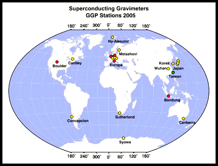
However, the national gravity reference long relied on the international gravity base point at the former Taipei Songshan Airport. As gravity measurements gained ever wider application, in 2003 MOI launched the National Basic Surveying Development Plan, of which the establishment of the National Gravity Reference Station was a key project.
Following the 921 Earthquake in Taiwan and the Indian Ocean earthquake-tsunami, the urgency of building a national gravity station that could serve as a foundation for hazard mitigation became even more apparent.